 |
| Lynmouth Cliff Railway |
Due to the vagaries of public transport at this time of year (April), the winter bus service was still in operation and the coastal bus link from Ilfracombe wasn’t in operation on the day I planned to do this walk and so I had to wait a further three days to complete this section. It was to be a major disappointment as the originally scheduled day was beautiful sunshine, possibly the best day of my week, while the day I actually walked it was drizzly and the atmosphere was heavy with mist, making visibility quite poor.
 |
| Foreland Point From Lynton |
I ducked out of climbing the hill from Lynmouth to Lynton, primarily because I had done this about a year beforehand and learned the hard way how steep it was. I instead started my walk at Lynton, taking about half mile off the total. I was the only passenger from Coombe Martin to Lynton on the bus, so perhaps it wasn’t surprising that this service doesn’t run every day. I got off in Lynton High Street and stocked up on provisions before getting underway. The path resumed off the High Street and across the cliff railway, which had just started up for the day. The view across towards Foreland Point was quite spectacular, even through the mist. Along the first part of the road were several hotels that took advantage of this view and I suspect that they are wonderful places to stay.
 |
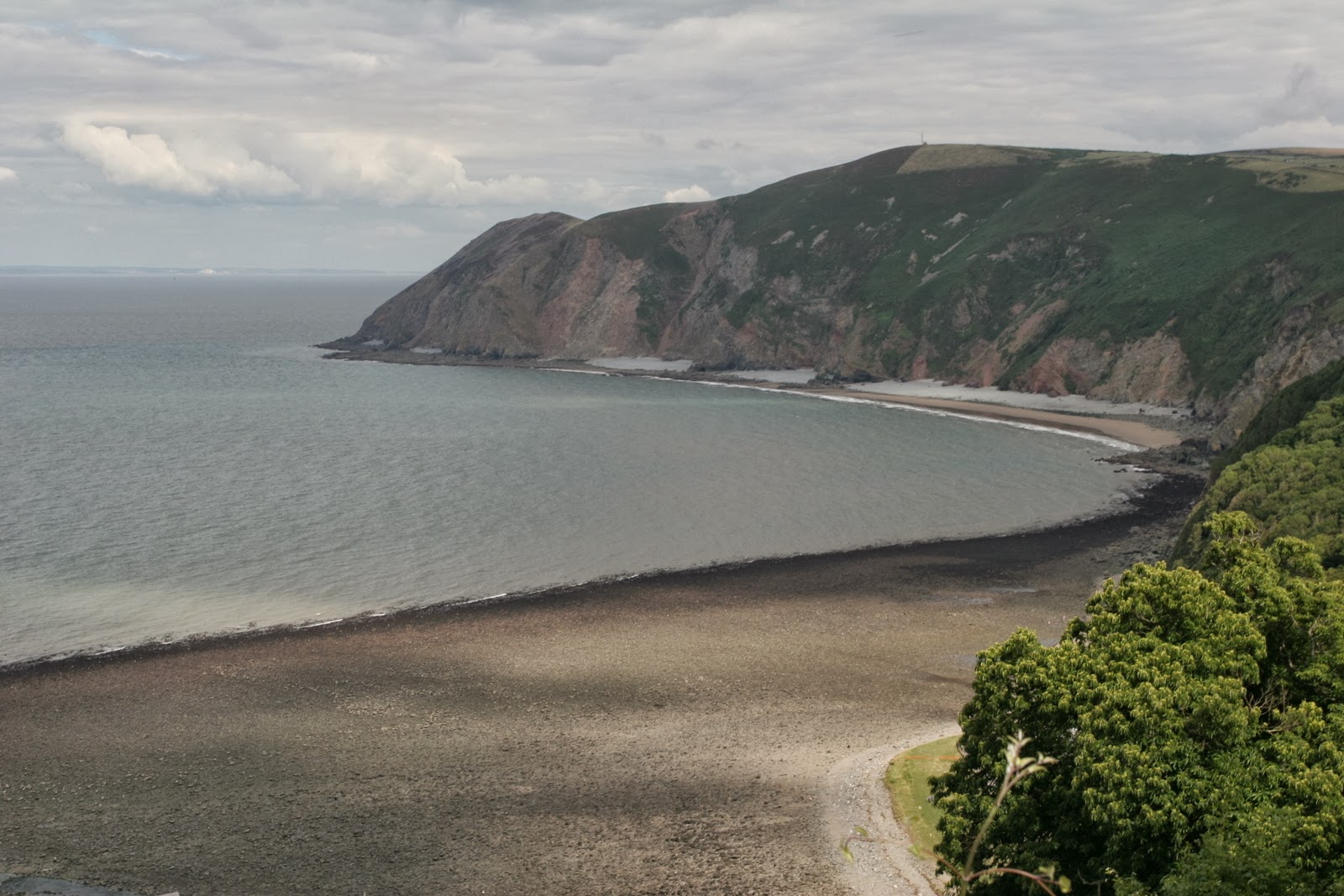
| Valley of the Rocks |
The road petered out and became a tarmac surfaced footpath, continuing through the trees for a short while. As I continued I could see the slope either side of me getting a little steeper and soon the path appeared to cling to the side of a cliff! The going was pretty easy however and I soon reached Castle Rock, a feature that needed no other description when I reached it! The view along the coast was pretty spectacular at this point and showed me what I would have to achieve to reach my goal today. I was a little worried about the weather as this was possibly the loneliest section of path so far and there were few escape routes. However, I pressed on hoping that the weather would improve.
 |
| April Fool |
When I reached the Valley of the Rocks I soon became aware of the goats that lived here. Although they were feral, they didn’t seem to notice my presence too much and wandered quite close to me. They also didn’t seem to mind the weather or terrain conditions as they wandered freely among the rocks and in the windiest of spots.
 |
| Lee Abbey |
From here it was back to road walking for a bit, through the Lee Estate and past a fairly impressive looking Lee Abbey, which wasn’t as old as the name suggested (or even that abbey like, come to that). All was deserted today, although ahead I saw some fellow walkers who were obviously prepared to brave the conditions. At the bottom of the hill, I passed a toll cottage that was still in use! The charge for driving across the Lee Estate was the princely sum of 50p, although these days the toll was collected by an honesty box rather than a tollgate keeper. As the path ascended, there was a turning to the right signposted as an alternative route. I opted to take it, to relieve the monotony of the road. The view back to Lee Abbey was enjoyable and on the hill immediately above I could see a lookout tower peeking out of the trees. I am sure that on a better day this would have afforded good views across to Wales. I enjoyed the alternative route, although it did prove to be very hard going as the path dropped back all of the height gain from the road. I caught the couple ahead at this point and cruised past them. They didn’t seem too bothered about speaking to me, so I carried on by. After looping around the coast a bit the path returned to the road but not before a fairly stiff climb through the trees.
 |
| Lee Toll Cottage |
This was the road to Woody Bay, a hamlet that started out with grand designs on becoming a successful seaside resort. Originally a pier was built for passing steamers and there were also plans for a railway station on a short link to the narrow gauge Lynton-Barnstaple Railway Line. This never materialised and Woody Bay station (recently restored and reopened to the travelling public on a preserved line) stood nearly two miles away. Unsurprisingly given the logistics and the fairly poor quality beach, Woody Bay never made it but is now an absolutely fabulous spot for those lucky enough to have a house here.
 |
| Lee Abbey Setting |
The road in was a little hairy, with a very steep drop away into the sea on one side and a carriageway that was scarcely wide enough for one vehicle. There was a belated crash barrier close to the village, but this would only have protected you for a very short stretch of the road. As I reached Woody Bay itself the path left the road entirely and passed through some very thick woods. It was here that I realised that I had no mobile phone signal, perhaps not surprising given the terrain. The path had the impression of an abandoned road in this area, as there were telegraph poles alongside and some engineered sections including a fairly substantial bridge across one of the many hillside streams.
 |
| Cow and Calf |
The path continued around a headland and eventually I left the trees behind and entered open countryside. This gave a better feel for how steep the terrain really was and a little further along the coast the path passed by a waterfall for yet another of the Exmoor streams. As I rounded the corner past the waterfall, the path stretched away from me through a heather clad hillside to the next headland. This was possibly the most spectacular part of the coast so far and as I rounded the corner of this headland I saw the enormous valley of Heddon’s Mouth. Across the other side of this steep valley I could see the path continuing around the headland and I knew that I would have a very energetic half an hour ahead of me.
 |
| Woody Bay |
The path descended diagonally into the valley away from the mouth of the river and the initial windy blast that I got at the top was mercifully short-lived. By the time I got down into the valley it was hard to believe that I was so close to the Devon coast as the countryside resembled the Yorkshire Dales or the Lake District. It was also relatively warm once again, which wasn’t terribly helpful as I climbed the other side of the valley. On the way up I passed a large group of young people, probably Scouts or Guides who were having a breather before heading out on to the exposed piece of coast once again.
 |
| Looking Over Woody Bay |
At the mouth of the valley the path swung round 90 degrees to resume its course along the coast. I was again met with a blast of cold wind and all I could see ahead was swirling cloud. It was a little daunting, knowing that I had several miles ahead of me with these conditions. Views were almost non-existent and the cloud base seemed to be getting lower all the time. Eventually the path that had clung to the rocky slope gave way to slightly less forbidding terrain and headed up the slope on to a grassy area on the side of a field. This is where I entered the cloud base and the next half a mile or so was completely shrouded in mist, with visibility no more than about 50 metres.
 |
| Heddon's Mouth |
A little further on I came across a mile post advising me that there was still six miles left to walk until Combe Martin. I also met a small group of hikers going in the opposite direction, which reassured me that perhaps conditions weren’t that bad. However for the next half an hour or so I saw nobody else until reaching a stony track. When I got here I saw a couple of people ahead of me, clearly lost. They told me that they had lost their map in the wind and their walking guidebook only had directions, which they couldn’t make head or tail of. It soon became obvious that they had overshot their turning by about a mile and it was therefore little wonder that they didn’t have a clue where they were.
 |
| Great Hangman |
Shortly after this encounter the path again veered inland and I was rather horrified to note that I was to have to negotiate another steep sided valley in order to continue on my way. The only fortunate thing was that by descending to sea level almost once again, I was able to get out of the penetrating wind. This time there was no route along the valley floor at all and the path went straight back up the other side. It was a pretty stiff climb and went on and on to the top of what promised to be the highest point on the whole South West Coast Path, Great Hangman. Of course, when I got to the top there was little or no view because I once again entered the cloud layer. I passed the cairn at the top and didn’t hang around, descending the other side as quickly as I could.
 |
| Descending to Little Hangman |
After about 10 minutes of descending the dark form of Little Hangman came into view and a little after this everything suddenly became clear once again and I knew that I was over the worst of it. Combe Martin still looked a long way down from the top but by now I was quite keen to finish my day’s walking. As soon as I got mobile phone reception I rang my colleagues at work to see how they were getting on, so relieved was I to have contact with the outside world once again. After about another half an hour of practically running downhill I got the long village of Combe Martin, strung out along yet another of the steep sided valleys that are so abundant in this part of the world. Today I was without car entirely, but I didn’t have to wait long for the bus back into Ilfracombe.
 |
| Little Hangman |
PostscriptThe following day, after I had been out all day, the weather had improved to such an extent that I was able to watch the sunset from the top of Great Hangman. The views that had denied me were plainly evident and were truly magnificent, across to South Wales and along the coast back to Lynton and the Valley of Rocks as well as along the coast towards Watermouth and Ilfracombe.
 |
| Coombe Martin |
Later in the summer (August) I retraced this walk with my brothers-in-law. The weather was warmer but visibility wasn’t a lot better.


No comments:
Post a Comment